About this project
Project Location and Background
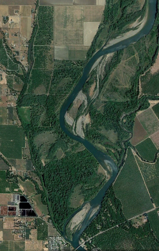
This project, led by the California Department of Water Resources (DWR), is located on the Sacramento River near the City of Corning and the Town of Vina in Tehama County. The confluence of Deer Creek is located on the left bank of this reach of the river. The Woodson Bridge State Recreation Area, Kopta Slough, Tehama County River Park, Woodson Bridge, and the Sacramento River National Wildlife Refuge Rio Vista Unit are located in the downstream portion of this reach.
The Kopta Slough Property (Property) lies within the natural meander belt of the Sacramento River where the main channel once flowed across the lower portion of the Property. In 1963 the U.S. Army Corps of Engineers (USACE) and Central Valley Flood Protection Board (CVFPB) (formerly the Reclamation Board) placed rock revetment along the Sacramento River right bank from River Mile (RM) 220 to approximately RM 221 to protect orchards on the Property, reduce erosion, stabilize the main river channel, and reduce sediment in the river.
The orchard lands have since been restored to riparian forest that thrives with periodic flooding and no longer requires bank protection.
Project Partners
- The Nature Conservancy
- U.S. Fish and Wildlife Service
- California Department of Parks and Recreation
- California Department of Fish and Wildlife
- Sacramento River Forum
- Tehama County
- Tehama County Flood Control and Water Conservation District
Project Objectives
- Restore, enhance, and conserve floodplain habitat.
- Restore hydrologic and geomorphic function
- Improve fish and wildlife habitat.
- Reduce flood management system operation and maintenance costs and responsibilities.
- Facilitate the enhancement of recreational opportunities.
Project objectives support multiple system-wide planning efforts, including the Central Valley Flood Protection Plan, California Water Action Plan, Water Resilience Portfolio, Central Valley Project Improvement Act , and Framework of Voluntary Agreements, and are consistent with DWR’s Environmental Stewardship Policy.
Project Description
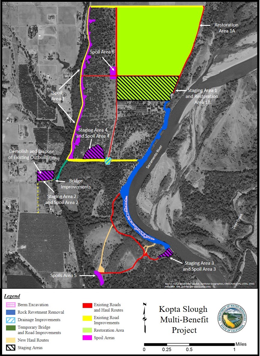
The project consists of three elements:
(1) Full removal of approximately 5,600 linear feet of existing rock revetment along the Sacramento River bank bordering the Kopta Slough property to restore natural fluvial and geomorphic processes and allow for the establishment of riparian habitat. Rock revetment will be removed from the landside of the bank. The existing natural berm behind the rock revetment will be excavated and recontoured to match the existing floodplain elevation.
(2) Restoration of the 176-acre agricultural field to native floodplain habitat on the Kopta Slough property. What is typically alfalfa will be restored to 46 acres of native grassland, 45 acres of valley oak woodland, and 85 acres of valley oak riparian forest.
(3) Transfer of the Kopta Slough property to U.S. Fish and Wildlife Service (USFWS) ownership to assure its long-term management and conservation, as well as facilitate the enhancement of public recreational opportunities. USFWS will develop a management plan that will describe the potential recreational uses and opportunities for the property.
Project Benefits
The project location provides an opportunity to remove rock revetment to achieve the project objectives of restoring, enhancing, and conserving floodplain habitat; restoring hydrologic and geomorphic function; improving fish and wildlife habitat; and reducing flood management system operation and maintenance responsibilities that can adversely impact fish species. Project implementation is anticipated to benefit all Chinook salmon runs by increasing the area of available rearing habitat in this reach of the Sacramento River.
Restoration Consistency Determination
The Restoration Consistency Determination with CDFW was acquired for state and federally listed Sacramento River winter-run Chinook salmon (Oncorhynchus tshawytscha) and Central Valley spring-run Chinook salmon (Oncorhynchus tshawytscha), after the project was covered under the Central Coast NMFS Programmatic Biological Opinion (PBO).
Proponent
California Department of Water Resources
Status
To be implemented
Type of project
- Floodplain restoration
County or Counties
- Tehama
Watershed
Sacramento River
Project size
Approximately 176 acres of floodplain restoration, 5600 linear feet of rock revetment removal
Project documents
- Final Initial Study/Mitigated Negative Declaration
- Mitigation, Monitoring, and Reporting Program under CEQA
- CEQA Notice of Determination
Permitting pathways used
- Central Valley NMFS Programmatic Biological Opinion (PBO)
- CDFW Restoration Consistency Determination (CD)
- USACE Regional General Permit 16 – Aquatic Habitat Restoration and Enhancement Activities (Sacramento District)
- A Section 106 Concurrence was received from the State Historic Preservation Office.
- An individual Biological Assessment/Biological Opinion was completed for this project for listed species with USFWS, and was completed before the USFWS Statewide Restoration Programmatic Biological Opinion (PBO) was issued.
- An individual project Section 401 Water Quality Certification was acquired from the Central Valley Regional Water Quality Control Board, and was completed before the Water Board Statewide Restoration General Order (SRGO) was adopted.
- Acquiring the remaining permits for the project is still in process.
Project photos